Advertisement






The Gulf conflict has disrupted global supply chains, pushed...
REITs have changed the way commercial real estate is owned a...
What really powers the cloud? Behind every Google search, A...
What really powers the cloud? Behind every Google search, A...
Luxury real estate is one of the most talked-about segments ...
The Mumbai Metropolitan Region Development Authority (MMRDA) has completed three Existing Land Use (ELU) reports covering Mumbai 3.0 and Mumbai 4.0 in two-and-a-half months. The reports cover around 2,008 square kilometres across 565 villages in KSC New Town, Palghar’s Northern Extended Notified Area and Southern ENA in Raigad, including Alibag. Using LiDAR, high-resolution imagery, DGPS and GIS mapping, the reports provide data on land use, infrastructure, settlements and natural resources. The database will support master planning, development plans, digital twins, infrastructure planning, housing, employment and environmental protection across the region.
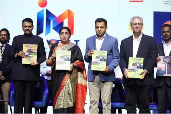
The Mumbai Metropolitan Region Development Authority (MMRDA) has completed three Existing Land Use (ELU) reports for areas covered under Mumbai 3.0 and Mumbai 4.0. The reports cover around 2,008 square kilometres across 565 villages and are intended to support future planning for connectivity, employment, housing and infrastructure.
The reports cover KSC New Town, the Northern Extended Notified Area (ENA) in Palghar and the Southern ENA in Raigad, including Alibag. MMRDA said the exercise was completed in a record two-and-a-half months.
The reports were handed over by MMRDA Metropolitan Commissioner Sanjay Mukherjee to Maharashtra Chief Minister Devendra Fadnavis at the Invest Maharashtra launch. Deputy Chief Ministers Eknath Shinde and Sunetra Ajit Pawar, along with other state ministers and dignitaries, were present.
The three reports use aerial LiDAR, high-resolution imagery, DGPS ground control and GIS mapping, along with cadastral records and field verification. The exercise maps settlements, terrain, infrastructure, natural systems and existing land-use patterns.
KSC New Town covers around 324 square kilometres across 124 villages in Pen, Uran and Panvel talukas. MMRDA is the New Town Development Authority for the area. The region is seeing development linked to Navi Mumbai International Airport, JNPA, Atal Setu and the Virar-Alibaug Multi-Modal Corridor, creating scope for urban, logistics, commercial and industrial growth.
The Palghar Northern ENA report covers around 1,007 square kilometres and 224 villages. The area includes forests, rivers, agricultural land, a 40-km coastline, mangroves, wetlands and tribal settlements. It is also developing as an industrial, logistics and tourism corridor, supported by MIDC Tarapur and road, rail and coastal connectivity.
The Southern ENA report covers around 677 square kilometres and 217 villages. The Alibag region has beaches, forts and other tourism and ecological assets, along with industrial and transport corridors. Future planning will have to account for agriculture, coastal protection, environmental conservation and disaster resilience.
MMRDA plans to use the ELU database for digital twins and scenario modelling. The database can be integrated with transport, utilities and environmental information to assess the impact of different development options on mobility, infrastructure demand, flood risks and access to services.
The planning exercise will also help identify locations for commercial districts, offices, industrial and logistics hubs, markets, e-commerce facilities and digital infrastructure such as data centres and AI factories. MMRDA said this could support job creation and investment while improving access to serviced residential land and affordable housing near employment and public transport.
The authority also plans to develop compact, mixed-use centres with schools, universities, hospitals, community facilities and public spaces. Tourism, heritage and local livelihoods will also be considered in future planning.
Around 45% of the combined study area falls under forest and green-area categories. MMRDA said it will work with relevant authorities to protect and restore mangroves, wetlands, rivers, water bodies and natural drainage systems.
The remaining land will be assessed for development suitability, conservation and restricted development through statutory planning and environmental assessments. Future proposals will also include parks, green networks, waterways and other blue infrastructure.
MMRDA said infrastructure planning will be carried out alongside green and blue infrastructure, with focus on public transport, energy efficiency, renewable energy, water-sensitive planning and climate resilience.
For KSC New Town, the database will support the master plan and future development proposals. In Palghar and the Southern ENA, it will support GIS-based Development Plans and proposed land use while aligning local planning with the wider infrastructure requirements of the Mumbai Metropolitan Region.
The next phase will use the ELU findings to prepare coordinated planning proposals and phased infrastructure investments. MMRDA said the objective is to create connected growth centres and distribute employment, housing and services across the region rather than concentrating development in a few locations.

20th Oct, 2026

3rd Oct, 2026

28th Sep, 2026

24th Sep, 2026



4th Aug, 2026


Advertisement








 Facebook
 Whatsapp

